Collection Gems: May 2017
This month’s guest author is Ray Simonds who worked for the State’s Geologic Survey several years before employment as a consulting geologist. Now retired, Ray is an very active member of the Hunterdon County Historical Society’s Cemetery Committee and is involved in local historical research as well.
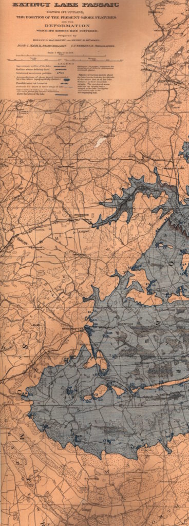
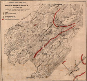
From 1854 to 1909 the State of New Jersey Geologic Survey published Annual Reports detailing new discoveries in New Jersey geology. In addition, economic geology was reported in the publications covering the mining industry in the State based on the reporting year. While reviewing the Historical Society’s map collection, four interesting maps, seemingly related, were found. All four of the maps, dated 1893, pertain to New Jersey geology and were included with the Annual Report, accompanying it in a separate tube. They are entitled: “Map showing the Distribution of Intra-morainic and Extra-morainic Glacial Drift” (Map 144), “Map of the Extinct Lake Passaic” (Map 131), “Map Showing The Direction of Glacial Striae on the Palisades Ridge” (Map 146), and “Map of The Vicinity of Hibernia” (Map 150).
 While all of these are interesting to the student of geology, two of the maps are of special interest even to the untrained person. The Map of Lake Passaic shows the approximate extent of the lake as it existed in northern New Jersey at the end of the Wisconsin Glacier approximately 14,000 to 19,000 years ago. The lake was formed as remnant of the Glacier melting and extended from above Lincoln Park New Jersey south to Far Hills, its southern end being effectively dammed by the hills of the Watching Basalts (see Figure 1). The discovery of the lake is credited to State Geologist George Cook in 1880. However, the Map included in the 1893 report was the first time the boundaries of the former lake were understood and depicted on a full size colored map. Many remnants of the extinct lake are still evident today, one example being the wetlands of the Great Swamp National Wildlife Refuge.
 Another map included in the report is a diagram of the Hibernia mining area in Morris County, New Jersey (Figure 2) For most of the 1800’s New Jersey produced the largest amount of magnetite (iron ore) in the country. Some of the largest mines in New Jersey were located in the vicinity of the town of Hibernia in Rockaway Township, Morris County. Mines in the area could run 600 to 800 feet deep with the largest employing over 300 workers. The map shows in detail the geology of the area with mine locations and towns associated with the mining area. The target formation consisted of gneiss (pronounced “nice”), containing quartz, feldspar, garnet, biotite mica, graphite and, of course, magnetite. The map also shows the road and rail system used to ship the iron ore to smelters around the state. If you are wondering what any of this has to do with Hunterdon County, the geologic formation extended into the northern portion of Hunterdon, tapering off around Clinton. Many mines – usually no more than small operations with names like High Bridge Mine, Annandale, Turkey Hill Mine, Bird Mine – were scattered across the area in the mid 1800’s. Most iron mines in New Jersey closed by the time the 1893 Report was published. Higher quality and quantity iron ore was discovered in the Lake Superior Region in Michigan. Some of the larger New Jersey mines briefly reopened in 1897 and 1917. Today you can still find remnants of the New Jersey iron mines, though most are on Private property.
