
Collection Gem: January & February 2018
This article is written by guest author, member and Trustee of the Hunterdon County Historical Society, Robert Leith. It is the first “non-map” Collection Gem, selected from the Society’s Manuscript collections and will remain on the Society’s website until March so you can try your hand at solving the mystery.
————————————————————————————————
One of my favorite pastimes is to look up old survey maps from the HCHS collection and try to find the modern day location. HCHS has a great collection of old survey maps, many however with unknown locations and therefore the maps lose value as a research document.
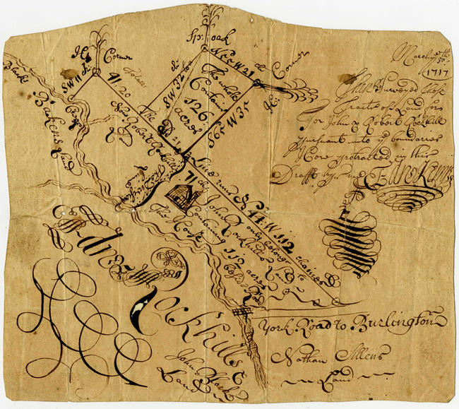
This survey dates to 1717 and is from HCHS Collection 18: Box 4 – Folder 118 “Survey land of John & Robert Rockhill 1717”. Figure 1 is shown approximately full size, the original being 7 1⁄2” by 6 1⁄2”; a very small page size for a survey of 112 acres of land. The flourishes and ornamental penmanship (doodles) caught my eye and took a while to understand that this was actually a survey map. When I realized it was a survey it made me smile. Who would do such a drawing; an engineer, an artist, a surveyor? Certainly someone with a flair.
There is a reference to “York Road to Burlington”, the survey has metes and bounds, (except York Road) there is a bridge going over a river, and Nathan Allen is an adjacent property owner, so I set out to find the location on a modern day map.
If you would like to try to solve this mystery for yourself you should stop reading and come down to the Deats Library where we will have a very good full scale copy of the survey that you can look at, touch and ponder, and try to find the modern day location yourself.
Starting with Google maps showing property lines, to scale, I looked up and down York Road in Hunterdon County, tried to align a creek with a property line, but found nothing. (By the way, when did York Road become Old York Road? I am thinking around 1800.) Next I made a 1” = 400’ transparency of the property and overlaid that on the tax maps, with the same scale, at the Clerk’s Office, but there was still nothing. Usually I would have found something by now, but I was stumped so I approached Marfy Goodspeed. She gave me some background on the Rockhills of Pittstown and then said “maybe it is not in Hunterdon County”.
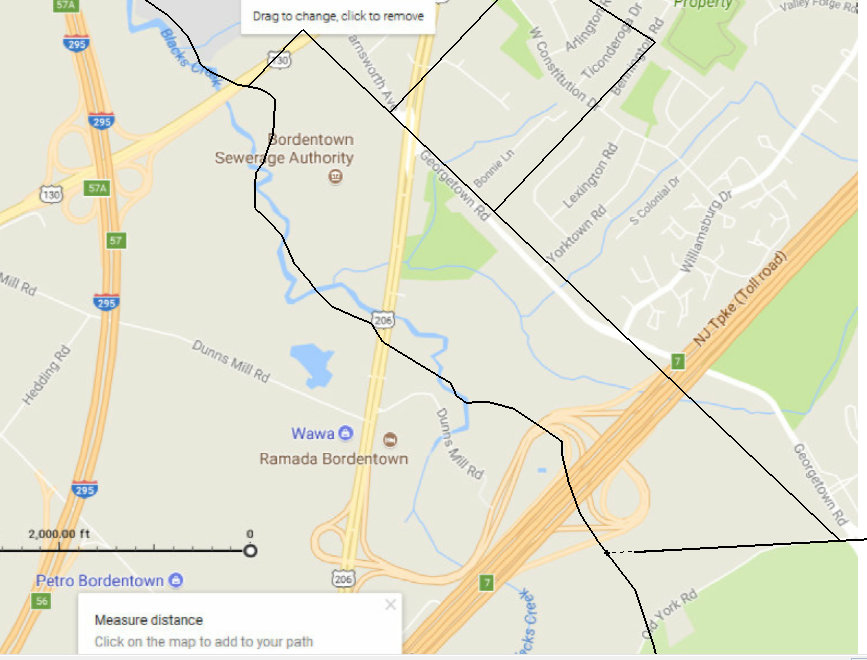 I went back to the survey map and noticed on the upper left was a hard to read notation for Black’s Creek. Ah-ha, this was a great piece of information. On Google Maps I followed York Road all the way down the state looking for an intersection with Black’s Creek. And there it was in Burlington County; present day Exit 7 of the NJ Turnpike. See the outline of the survey overlaid onto a modern map (Figure 2).
The northern part of the parcel became Georgetown Road, the western property line is now Route 130. The Turnpike construction changed the location of the river on the south side of the property along with a small part of Georgetown Road. York Road is very different in the modern map but no direction was called out on original survey map, as no direction was called out for Black’s Creek, just “York Road to Burlington.”
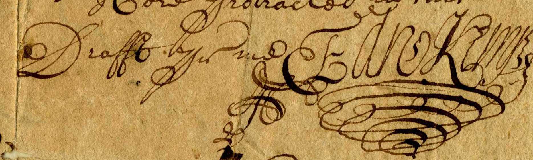
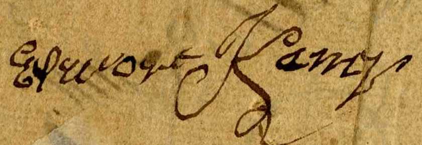
So who did the survey map? I believe it was Edward Kemp (see Survey side signature below). “Draft by…Ed – Kemp?” (Figures 3 & 4)
|
|
|
So how did this survey wind up in the HCHS collection? According to Snell’s “History of Hunterdon County” Edward Rockhill settled in Burlington County around 1680 and his son Edward moved to Pittstown around 1740. The “Quaker Meeting Records, 1681-1935”, show Edward and Mary Rockhill having a son John in 1683, a son Robert in 1692, and a son Edward in 1703. Possibly John and Robert are the recipients of the land on the survey map and Edward is the one who settled in Pittstown possibly bringing the survey map with him, and that map winding up in the HCHS collection.
As to Edward Kemp? See the story here at Goodspeed Histories.
Edward Kemp was a deputy land surveyor, Quaker and would have been about 68 if he did this survey. The Hopewell Museum has an original deed that Edward Kemp witnessed, hopefully I will be able to compare signatures. If not the Hopewell Museum, I will have to go to the Archives in Trenton. They also have witnessed deeds by Edward Kemp and perhaps an actual survey map by Edward. If the location is correct, Burlington County Historical Society should get a copy and HCHS will need to update the inventory list to include the location and key words for its search.
Note: If after reading this article you want to try your hand at locating an old survey map please let HCHS know. We will supply you with a very good copy of a survey and send you on your hunt.